In the Steps of Pioneers
A journey through the San Luis Valley reveals the influences of Native Americans, Hispano pioneers, Mormon settlers and Homesteaders, as well as ranchers, farmers and prospectors. These groups converged within the Valley prior to the 20th century. Each brought a unique set of cultural traditions, many of which endure to this day. Travel mileage: 242+ miles
Photo above: Mural located in the town of Antonito on old silos at the corner of 8th and Main.
Painted by Fred Haberlein
1 – Montville Nature Trail and Mosca Pass Trail (Great Sand Dunes National Park and Preserve) – The self-guided Montville Trail is a half-mile loop that parallels Mosca Creek and leads past the remnants of a historic toll station. For a longer hike, visitors may take the Mosca Pass Trail, which winds through aspen and evergreen forests to the summit of a pass in the Sangre de Cristo mountain range. Mosca Pass served as an entrance to the Valley for nomadic hunters, Spanish soldiers, homesteaders, and traders carrying goods bound for Plains Indian tribes. In 1807 Zebulon Pike, author of the earliest known written description of the Great Sand Dunes, passed nearby with his men, enroute to the river and the valley floor. Summer: 9am-6pm | Spring and Fall: 9am-5pm | Winter: 9am-4:30pm | http://www.nps.gov/grsa/
La Sierra Blanca - Mt. Blanca - Sisnaajini. Photo by Kat Olance
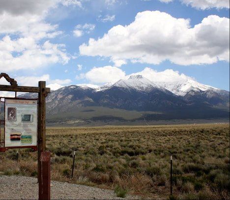
2 – La Sierra Blanca (aka Mt. Blanca) – Towering 6,000 feet above the valley floor, Colorado’s fourth highest peak (elevation 14,345’) commands your attention. Native Americans ascribe special significance to this landmark peak. The Navajo count it as one of the four sacred mountains, as it marks the eastern boundary of their traditional homeland. They called it Sisnaajini, meaning “white shell mountain”, perhaps due to the snow that frequently persists into late spring.
3 – Fort Garland Museum – Designed as an outpost to facilitate settlement in Ute country, Fort Garland served many purposes in its 25-year history. The command of Kit Carson from 1866 to 1867 brought peace with the Utes and food for the impoverished tribes. During the Civil War, Union troops trained here. After the war, Buffalo Soldiers were stationed here for several years. The Fort was abandoned in 1883 but later restored by the Colorado Historical Society.
March 1st - October 31st - 9am - 5pm daily
November 1st - December 31st - 10am - 4pm Wed - Sat
January 1st - Feb 28th - closed
4 – San Luis People’s Ditch and La Vega – Two landscape features near the town of San Luis illustrate traditional land uses. Built in 1852, the San Luis People’s Ditch is the oldest irrigation system in continuous use in Colorado and was the result of the first water right application in the state. The Spanish word for these waterways is acequias. Another unique landscape feature in San Luis is La Vega, a public commons. La Vega continues to be used for its originally intended purpose–communal grazing. Founded in 1851 by Hispano settlers, San Luis is the oldest continuously occupied settlement in Colorado. To find out more about the acequias and the history of the town make sure to visit the Sangre de Cristo Heritage Center.
Oral History: Pages 6-16 of this PDF -
The Settlement of the San Luis Valley" discusses the beginnings of the San Luis Valley, Colorado. This written oral history is part of a collection with History Colorado "The CWA Pioneer Interviews are the result of a project led by the Civil Works Administration in Colorado in 1933-34."
Below is an oral history file from the Rio Grande County Museum's collection. The recording is of Vess Quinlan on the topic of Water in the San Luis Valley."
5 – Rio Grande - Vargas Crossing – In 1694 Don Diego de Vargas, the governor-general of New Mexico, led a band of Spaniards north into the San Luis Valley to avoid ambush by Pueblo tribes after he raided the corn stores of several villages to feed hungry Spanish settlers in Santa Fe. On the way back to Santa Fe, his party crossed the Rio Grande at an island near the current CO Hwy 142 bridge. In pioneer days, the site became heavily used as the Costilla ferry. A marker at the bridge commemorates this crossing. The Conejos County Museum (also a satellite office for the Sangre de Cristo National Heritage Area) can provide more detailed information of this part of southern Colorado.
San Luis, Colorado - People's Ditch
6 – Conejos Plaza / Courthouse Square – In 1854 Lafayette Head, who later became Colorado’s first lieutenant governor, built a fortified plaza on the banks of the Conejos River. Now known as Courthouse Square, this plaza in the center of Conejos is the site of Our Lady of Guadalupe Catholic Church, the oldest parish in Colorado, and other historic buildings.
7 – Pike’s Stockade – Soldier and explorer Zebulon Pike led the first major U.S. expedition into the Southwest. In 1807 Pike’s men erected a stockade at this site on the banks of the Conejos River and raised the American flag, though the stockade stood on Spanish soil. A replica of Pike’s stockade, reconstructed from notes in his journal, now stands on the site, which is designated as a National Historic Landmark in recognition of its exceptional historic significance.
For information contact:
719-379-3512 @ the Fort Garland Museum
719-274-4382 @ Sanford Museum
8 – Old Spanish Trail Markers – In several places, the roads and highways of the Valley intersect the Old Spanish Trail, a historic trade route linking Santa Fe, NM with Los Angeles, CA. This route followed even earlier routes established by Native Americans. In 2002 the Old Spanish Trail became part of the National Historic Trails system. For information from the local chapter click here: La Vereda del Norte Chapter - Old Spanish Trail.
9 – Colonel Pfeiffer’s Grave – Colonel Albert Pfeiffer, a comrade of Kit Carson, was well known and respected in southern Colorado and northern New Mexico for his bravery. He established himself as fur trapper, pioneer, soldier, and Indian Agent. Pfeiffer secured Pagosa Springs for the Utes by fighting and beating a Navajo warrior. Pfeiffer’s fringed buckskins are on exhibit at Rio Grande County Museum. His gravesite rests near the town of South Fork on land given to him in tribute by his Yutah (Ute) friends.
To reach the gravesite, go west from Del Norte on US160 for 8.4 miles, turn right/north on Rio Grande County Road 18, go 1.3 miles, turn left. Go 0.4 miles there is a sign on the right side of the road and a path going up to the site.
10 – Frémont’s Christmas Camp
– John C. Frémont entered the San Juan Mountains in the harsh winter of 1848-49 while exploring a transcontinental railroad route. Using compass and maps, hikers may follow U.S. Forest Service trails from camp to camp to experience firsthand this remote wilderness that became the scene of Frémont’s disastrous 4th expedition. The hike is 4.5 miles long and is rated moderately difficult. Mountain hikers should always consider their own fitness for hiking at high elevation, and should be prepared for severe weather even in summer months.
For information, contact USDA Forest Service, Rio Grande National Forest, 1803 W. Hwy 160, Monte Vista, CO 81144. 719-852-5941
11 – La Garita – La Garita, meaning “The Lookout,” was founded as Carnero Plaza. A variety of settlers have left their mark on the town since the mid-1800s. La Garita’s population never recovered after the flu epidemic of 1918 killed nearly half the town’s residents, buried at the San Juan Spiritual Center and Rosary Walk. A visit to the old plaza and its one remaining business, La Garita Trading Post, feels like a visit to an earlier era.
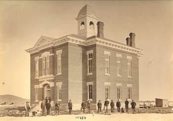
Saguache - Old County Courthouse
12 – Saguache County Museum – Among its many historic displays, the 50-year old Saguache County Museum houses Ute artifacts in the Native American Room and exhibits of memorabilia from the earliest Saguache settlers. The display in the 1908 jail depicts Alferd Packer watched over by Sheriff Wall. In 1874 Packer was actually held in a dungeon outside of Saguache after he was stranded in heavy mountain snow and survived by dining on his dead comrades.
Open daily from Memorial Day thru the 3rd Saturday in September, 9 am to 3 pm.
(719) 655-2805