Los Caminos Antiguos Scenic Byway
“You have entered the land of the Rio Bravo del Norte, the northernmost outpost of sixteenth century Spain. To the Spanish people, the San Luis Valley was a wild and unexplored place known only to the Native people. Amidst the beauty and towering peaks of the valley, the area became the center of conflict and wars born of a clash of cultures.” Point of Interest (POI) Sign at Cumbres Pass
The adventure starts from Colorado’s - Alamosa Welcome Center (corner of State Ave and 6th) to pickup maps and brochures for the sights you’ll be visiting. The Welcome Center is also the jumping off point for the Rio Grande Scenic Railroad to the town of La Veta. It is a wonderful train ride especially if you take one of their famous “Ride the Rails Summer Concert” trips. While in town, or on your return trip, stop at 1 of 3 museums in Alamosa - the San Luis Valley Museum at corner of 4th and Hunt Ave, the Ryan Geological Museum at Adams State University (ASU) (call ahead first), and the Luther Bean Museum at ASU (call ahead first). There is also a Walking Tour of the historic properties in downtown Alamosa including the Courthouse, Masonic Hall, and Locomotive No. 169 near Cole Park.
Try out the tour below or our 3-Day Itienrary that features all 3 of the Scenic Byways in the Mystic San Luis Valley
- Short Walks, Long Views - 203 Miles in the Mystic SLV
Now you are ready to hit the road!! You will head east out of town on Hwy 160 then turn left onto Hwy 17 going north. Turn right onto Rd 6N to go towards the Great Sand Dunes National Park. Just after turning onto Rd 6N on your left is a POI (N37 39.763, W105 52.224) where you can learn about Zebulon Pike and the Valley’s Spanish Land Grants.
“Our land grants ‘pueblitos’, or little villages, always began with the establishment of our church, or ‘iglesia’, and plaza as the spiritual and cultural center of everyday life. Under the sharp eye and wisdom of the ‘mayordomo’, or ditch rider, we shared a system of ‘acequias’, or irrigation ditches, that water our crops.” POI Sign on Rd 6N – The People of the San Luis Valley
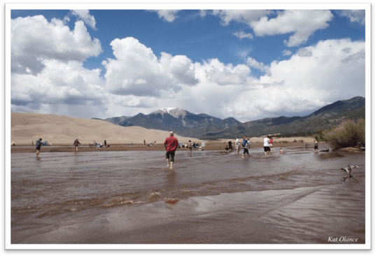
Spring flow of the Medano Creek @ the Great Sand Dunes National Park and Preserve. Photo by Kat Olance
Further down on Rd 6N will be the San Luis Lakes State Park (N37 39.980, W105 44.097). Continuing along on Rd 6N (heading east) is another POI, “Evidence of a Changing World” on your right (N37 39.757, W105 36.100) that provides wonderful panoramic views of the Sangre de Cristo and the Great Sand Dunes and possibly a view of some of the bison or horses from the Zapata Ranch to the south. On your next leg of the trip, make a left onto Hwy 150 north to visit the Great Sand Dunes National Park and Preserve, take your time there is lots to see, to learn and explore.
As you exit the Dunes take Hwy 150 south with another possible adventure just down from the Dunes at the Zapata Ranch (call for reservations) (N37 38.928, W105 35.079), a 103,000-acre ranch owned by The Nature Conservancy of Colorado. If you make reservations ahead of time they provide 3-7 day all-inclusive vacations that can include horseback riding, cattle branding, birding workshops, and Bison tours. Next on the road south stop at the “Waterways of Life” POI, on your right, (N37 38.261, W105 35.357), and then a bit farther south for a hike up to Zapata Falls (N37 37.709, W105 35.693).
“The cultural significance of the area surrounding the Byway can be directly linked by artifacts to some of the earliest known North American hunters, whose time frame is referred to as the Folsom Period. One San Luis Valley campsite has been dated to 10,900 years before present.” CDOT - Los Caminos Antiguos Scenic Byway Preservation Plan
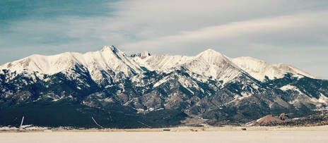
Just before the intersection of Hwy 160 is a Point of Interest (POI) (N37 28.650, W105 36.129) with some great information about the Sacred Mountain, Mt. Blanca, which is part of the Navajo Four Sacred Mountains. “We are the Diné (pronounced dee-neh) the Spanish called us the Navajo. We call the mountain that stands before you ‘Sisnaajini’ (White Shell Mountain).” The Navajo People - POI Sign on Hwy 150
Turn left onto Hwy 160, you are now entering into Costilla County heading through the town of Blanca and in to Fort Garland. At the intersection of Hwy 159 turn right with a must-stop at History Colorado’s - Fort Garland Museum (Colorado’s oldest still-standing military fort).
Next is a visit to the Costilla County Veterans Memorial Park (N37 25.569, W105 25.225) which is off a dirt road just slightly north/east of the Fort. The site commemorates veterans that served their country and includes a T-33A Shooting Star.
Whew! Depending on how much time you spent at the Dunes and Zapata Falls this might be a place for dinner at All-Gon Restaurant or Silver Sage Steakhouse and to stay overnight at a local motel, or campground before continuing on with the next portion of the trip. Otherwise let’s carry on.
“The primary cultural/historical feature of the byway is the Hispano heritage. Spanish explorers entered the San Luis Valley as early as the 1590's. The land was not empty. The Utes claim their ancestors traveled, hunted, and controlled the region for as many as 10,000 years prior to Spanish expeditions and settlements.” Los Caminos Antiguos Scenic Byway Partnership Plan
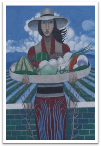
Mural in San Luis, CO
You continue the road trip south on Hwy 159 into the town of San Luis, Colorado’s oldest town established in 1851, as the town’s museum states, “Where Colorado Began.” There is so much to see and do around the town’s history, including the People’s Ditch, Colorado’s oldest water rights; R&R Market, Colorado’s oldest continuously operated business; the Stations of the Cross Shrine with statues sculpted by world-renowned local artist Huberto Maestas; and the town’s museum – Sangre de Cristo Heritage Center.
There are a number of historic properties and markers in San Luis including the Courthouse; the marker for the People’s Ditch (on the south end of town by Main and 1st St.); “Colorado’s Earliest Settlers” marker on the north end of town (N37 12.517, W105 25.505); and the Shrine Plaza marker (on Hwy 142 just off of the intersection of 142 and 159). San Luis is decorated with a number of murals including both sides of the building that houses the Ventero Open Press Fine Art Gallery and Huberto Studio & Gallery. Across the street is a potential lunch stop at Café Rosa Mystica.
You will head out of San Luis on Hwy 142 going west. Take a quick jog off onto RD 15 to check out Colorado’s oldest standing church building, Capilla de Viejo San Acacio (Mission of San Acacio). Continue west on Hwy 142 through San Acacio where you will find the San Luis Southern Railway Depot building, another of Colorado’s Historic Properties. Just after you cross over the Rio Grande River, stop and take in the views and location where Don Diego de Vargas forded the river in 1694. (N37 10.83, W105 43.890).
Costilla County, which you have been traveling through; Conejos County, which you are entering; and Alamosa County, where you started; are included in the recently established Sangre de Cristo National Heritage Area who are hard at work preserving and celebrating the extensive history and heritage of the area.
When you reach the town of Manassa, make sure to stop at the Jack Dempsey Museum, (N37 10.423, W 105 56.160) birthplace of the world heavyweight-boxing champion. Take a walk across the street to the historic marker for the Mormon Pioneers, one block east. Continue west on Hwy 142.
Turn left heading south on to Hwy 285 then making a right into the town of Conejos and stop in to see Colorado’s oldest church congregation, Our Lady of Guadalupe Church (N37 05.302, W106 01.175). Conejos is also the town where Colorado’s first Lieutenant Governor lived and is buried in the Conejos Cemetery (N37 05.033, W106 01.163).
“Other stories are woven into this cultural landscape. These include stories of European trappers and traders and their encounters with the Utes and Spaniards; of the expansion of railways into the region; of the birth of new towns with diverse heritages; and of water and land fights that continue into the present. The land and its stories continue to draw travelers and settlers. The ancient roads live on.”
CDOT Los Caminos Antiguos Scenic Byway Partnership Plan
As you leave Antonito you'll take the last leg of the Los Caminos Antiguos Scenic Byway heading on Hwy 17 south through Mogote and towards the Conejos Canyon area and on up into the Rio Grande National Forest. For thousands of years, nomads gathered berries, herbs, roots and nuts on this high pass, hunting antelope, bear and bighorn sheep. The La Manga Pass and Cumbres Pass provide spectacular views and additional history on the early settlement of the area and information about such valley residents as world-famous weaver Eppie Archuleta.
So ends the Museum of the San Luis Valley’s – Valley Adventure Road Trip of the Los Caminos Antiguos Scenic Byway but there is still a bit more history that can be enjoyed within the Sangre de Cristo National Heritage Area …
To close the loop (returning back to Alamosa) and to experience more of the history of this portion of San Luis Valley …. Turning around head north on Hwy 17 back through Antonito. Pick up Hwy 285 north towards the town of La Jara. Just after the turnoff for Manassa is a monument on your left (N37 10.684, W105 59.207) for the Citizens of Conejos County that lost their lives fighting during WWII. When you reach the town of La Jara make a quick stop at the Town Hall building a historic renovated Train Depot (N37 16.512, W105 57.623).
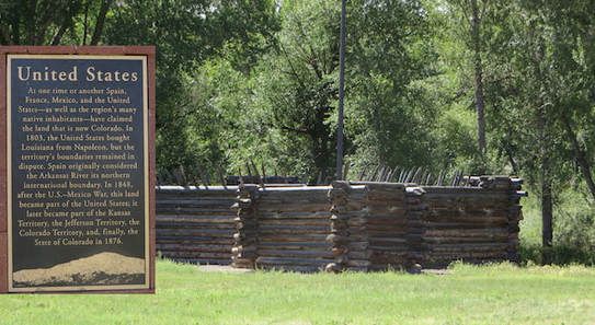
From La Jara’s Depot you will head south on Broadway. Turn left onto Rd W/Cnty Rd 136 over to Sanford to get a tour of the Sanford Museum (call ahead) (N37 15.422, W105 54.326). Next you can go to the National Historic Landmark of Pike’s Stockade (N37 17.890, W105 49.178) where Lt. Zebulon Pike and his men, in 1807, built a fortification to protect them against the hard winter. To get to the Stockade from the Sanford Museum head north up Main St north to where it “T”s, merge right onto Rd W/Ash St. Turn left at Rd 20, then a right at Rd Y (a dirt road). Follow Rd Y to the entrance for the Stockade. If the gate is closed there is a on-foot-walk-around (the stockade is another 8/10th of a mile down the dirt road). To head back to Alamosa just head north on Rd 24 (a dirt road) through the beautiful farmlands back into Alamosa and the completion of the Los Caminos Antiguos Scenic Byway through some of Colorado's earliest history.
Below is a reading of an oral history transcript of Anita Cordova. Ms Cordova recounts her growing up in La Jara, living on a ranch outside of Alamosa, attending Adams State College, getting married, moving and raising a family in Garica, CO.
“Come take a walk with us. We know an old song, El Caminante, which tells of taking a long walk along the ancient roads. Like the first prehistoric inhabitants, you too are a ‘caminante’, or one who walks upon this land.” POI Sign on Rd 6N– The People of the San Luis Valley